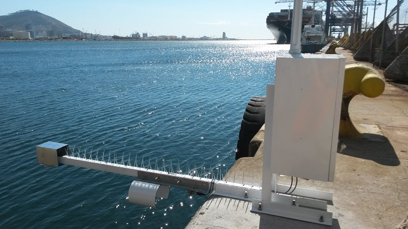
LOG_aLevel은 원격 감지, 독립형 Water Level Gauge (Tide Gauge)입니다. 이 시스템은 초음파, 레이더 또는 압력 센서로 작동할 수 있다. 그것은 매우 튼튼하고 믿을 수 있으며 모든 종류의 수위와 파도 역학 (up to steep waves)의 정확한 측정에 사용됩니다.
이 시스템은 Datalogger, 데이터 통신 시스템 및 추가적인 수문 및 기상학적 시스템을 포함하여 쉽게 확장되어 완전한 모니터링 관측소를 형성할 수 있습니다. 또한, 여러 LOG_aLevel 관측소를 상호 연결하여 하나의 네트워크를 형성할 수 있습니다. SCADA시스템과의 통합도 지원합니다.
Mobile Tide Gauge인 경우, 여기를 클릭하십시오.
해상 플랫폼용 Tide Gauge인 경우, 여기를 클릭하십시오.
LOG_aLevel 초음파 파고계 특징
- Easy to install
- Cost effective
- Extremely Robust & reliable
- Calibration-Free
- Maximum Accuracy at all times
- Maintenance-Free
- Reliable under Extreme Conditions: Flood, Ice, Storms, Debris, etc.
- Narrow Ultrasound Beam for Accurate Level even at Wavy Water Surface
- Simultaneous Wave and Level Measurement
- Extension With Additional Sensors (Redundancy, Meteorology and Hydrology)
- Remote Data Transmission, Control and Alerting
- Easy Integration to Measuring Networks
- Reduced risk of malfunction in case of flood and ice (no frozen level gauges!)
- Fast measurements (measurement of steep waves is possible)
- Remote sensing without influence to water surface
LOG_aLevel 초음파 파고계 제품사양
- Stainless steel housing, IP 66, lockable, size: 300x300x200 mm (or 500x500x200 mm)
- Ultrasound sensor ULL15040, IP 68, measuring range 6 m
- REF300 sound velocity sensor for precise distance measurement
- Controller module for signal processing and sensor control/data acquisition incl. RTC
- RS232/RS485 data interface
- Power supply 12 VDC
- LOG_aLevel Software for system set-up, online-analysis of measuring network, visualisation, managing and storing of data on a Windows PC
- Measuring range: 6, 8, 10 m
- Resolution / Field accuracy: 1 mm / 1 cm
- Sample rate: up to 5 Hz (user selectable)
- Ultrasound sensor: 80 kHz, narrow beam
- Working temp: -20 °C up to +70 °C
선택사항 – LOG_aLevel
- Ultrasound, Radar and Pressure Sensors
- Power autonomy: Backup battery up to 200 Ah, Solar Power, Wind Power
- Data logger with SD memory card (4GB / 8GB)
- Data transmission: Radio, GPRS, Satellite, Cloud, AIS, AIS AtoN
- Integration of any desired Hydrological and Meteorological Sensors (also in data stream, visualization and logging)
- Example Hydrological sensors: Water temperature, Inductive current meter, ADCP, Surface Current Flow, CTD, Salinity, Conductivity, Dissolved Oxygen, etc.
- Example Meteorological sensors: Wind gauge, Air temperature, Humidity, Rain, Ice, Solar Radiation, Barometric Pressure, Cloud Height, Visibility, complete Weather Stations and sensors for Helidecks, etc.
- Time: High accuracy GPS – date and time (pps, 1ms accuracy)
- Data Server / Database
- Website
- Alerting / Early Warning System
- Tide Analysis and Prediction
- Hypack – Export or Data Stream
LOG_aLevel 초음파 파고계 적용분야
- Water level and tide monitoring
- Coastal protection
- Harbor and Terminal Management
- Storm Tide, Flood and Tsunami Measuring Networks
- Hydrology and Environmental Monitoring
- (Temporary) Level Gauge to Support Dredging, Surveying and Construction Works
- Spectral Wave Energy Analysis for Optimal Survey Quality
- Water/Fluids Reservoir Management
- Wave Monitoring and Analysis
- Ship Induced Waves
- Load Determination for Hydraulic Engineering
- Torrent Monitoring
- Local Event Alerting e.g. Flood, Tsunami
- Real-Time Data for Vessels through AIS/AtoN
- Local Tide Analysis and Prediction System together with Tidepredictor Software
- Wave Measurements from Jack-Ups and Rigs
- Server-based Fleet Management Networks incl. Web Portal (e.g.Ferries, Water-Planes, Supply Vessels)
- Discharge Hydrographs
- Flood warning
- Identification of suitable locations for stationary monitoring stations
- Monitoring of multiple locations with a single Tide Gauge
Resources
LOG_aLevel Long Range Datasheet
UltraLab ULS Advanced Field Datasheet